|


_____________
In this section of
Gaspee History

_____________
Go to
Gaspee Raiders
for biographical
information on the Americans in the boats attacking the Royal Navy ship
Gaspee.
_____________
Books: American Colonial and
Revolutionary War history or the people involved. We have suggestions
for you.

_____________
Copyrighted.
© 2005
to 08/08/2010
Leonard H. Bucklin.
-----
The
content of this site may not be reproduced except for brief excerpts for
reviews or scholarly references..
See
Copyright Notices,
Privacy Policy, and Warnings & Disclaimers.
_____________

This is a history education and
research web site of the
Joseph Bucklin Society.
 References
in brackets [ ] or in curly brackets { } on any page in
this website are to books, or other materials, listed in the Joseph
Bucklin Society Gaspee Bibliography, or to materials held by the Joseph
Bucklin Society. References
in brackets [ ] or in curly brackets { } on any page in
this website are to books, or other materials, listed in the Joseph
Bucklin Society Gaspee Bibliography, or to materials held by the Joseph
Bucklin Society.
|

|
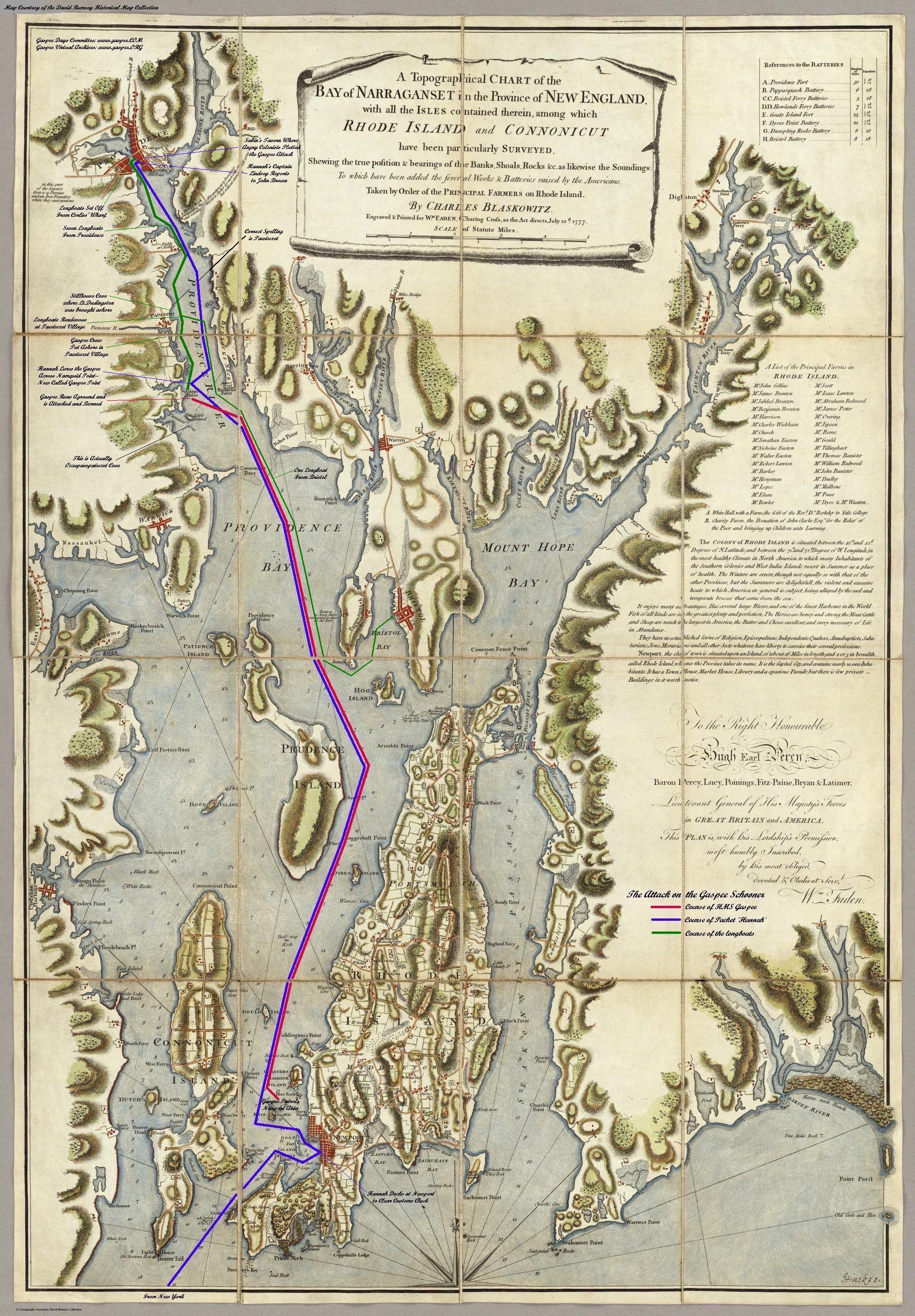
Important geography of the Gaspee attack
includes, moonlight, tides, and distances.
Moonlight. The attack
came at a date and time when darkness favored the surprise attack of the raiders
on the Gaspee. In Sessions' deposition of the Gaspee crewmen the morning
of the attack, they told him that by the time of the initial attack at about 12:45 a.m.
on 10 June 1771, the
moon was down and that it was dark.
Yet, as to the moonlight present, Lieutenant Governor Darius
Sessions stated in his testimony that at about 9 p.m. the moon had shown very brightly in
Providence on June 9th. What at first
appears a discrepancy is not one. The moon at the time of the attack later that
evening was different than at 9 p.m. The attackers, with their muffled
oarlocks, moved in the best possible conditions for their surprise attack,
starting their movements in moonlight, but attacking in darkness.
Colonial America did not have the concept
of time zones. Time zones were not invented until more than a century
after the Gaspee attack. Instead, colonial clocks in Providence would have been set for a local mean time (LMT), which was based on their own local meridian
of longitude, in this case about 71.4 degrees west, and not for the 75
degrees west on which EST is now based. At 9:14 p.m. LMT at Providence in
1775, the moon had an altitude of 35 degrees, which would have made it a bright
light in the sky (as Sessions testified). However, the moon was fully set by 1:00 a.m.
We doubt that the crewmen who testified as to time had any ability to know the
time when they were roused from sleep to come on deck without putting on clothes
for an emergency defense of the vessel. Even
assuming 12:45 a.m. LMT was the literal time (to the minute) when the attack
began, the moon would have peeped only 2.5 degrees above the horizon and setting
fast -- certainly not providing any significant illumination. Because
sunrise on the morning of the 10th occurred at about 4:24 a.m. LMT, there was a
period of about three hours of no moon or sunlight.
The above information on the moonlight and the following
information on tide were provided us true experts who on our request volunteered
their time and efforts. Those experts are Donald W. Olson, Department of
Physics, Texas State University, and Roger W. Sinnott, Senior Editor, Sky &
Telescope. Sinnot is not only the senior
editor of Sky and Telescope (the essential magazine of astronomy), but
also is
the author of a number of books on what can be seen in the sky. A minor planet
is named in his honor because of his work. Further, Sinnott, in 1994, started
Sky and Telescope's Astronomical Computing department to make accurate
celestial calculations of historical or future sky happenings, and wrote the
necessary computer programs. The computer programs he has written
now are used extensively to
derive star positions and star charts. Olson has written many acclaimed articles about the effect
of tides at the invasions of D-day and Tarawa in World War II, and also the
tides at such events as Paul Revere's ride and the Boston Tea Party.
Because of the computer computations of this tide expert, we can also state with
certainty what follows about the tides (times and heights) at the time of the
Gaspee attack.
Tides. The attack took place in a tidal river area. The tide was going out (ebbing) at the time
on June 9th when Gaspee went aground. Although the tide would have been
starting to come in (rising) when the attackers left Providence, a high enough tide
to float the Gaspee would not have occurred until the afternoon of June
10th.
Providence. and nearby Gaspee point, (at Latitude - N41.807. Longitude
-WN71.402) on 06/09/1772 to 06/10/1772 at Local Standard Time had the following
tides.
|
Date 1772 |
High |
feet |
Low |
feet |
High |
feet |
Low |
feet |
|
06/09/ |
01:57 |
4.63 |
07:20 |
0.03 |
14:31 (2:31pm) |
5.11 |
20:02
(8:02pm) |
0.36 |
|
06/10/ |
02:56 |
4.60 |
08:22 |
0.01 |
15:30 |
5.35 |
21:09 |
0.23 |
Bartholomew Cheever and John Johnson, Gaspee crew members, stated in
their depositions that the schooner had run aground on Namquid Point at about 3
p.m. on the afternoon of June 9th, 1772, to wit a half hour after a high tide of
5.11 feet.. The tide was ebbing when the Gaspee
went aground. The next high tide of 4.60 feet at 2:56 a.m. most likely would not have been
sufficient to float a vessel that had run aground only a half hour after a high
tide of 5.11 feet the preceding day. Most likely this was recognized by
Lieutenant Dudingston, who had his crew sleeping for the night, instead of using
efforts to free the ship as the evening tide came in. A higher tide of 5.35 feet that would have
been presumably sufficient for the task, would not have occurred until 3:30 p.m.
on the afternoon of June 10th.
Additional moon and tide information is found in
the materials at
Gaspee.Org.
It is interesting to speculate that the grounding of the Gaspee and the
attack on it was planned well in advance. Such speculation could be based
on the fact that the combination of this favorable time and
size of tides and the favorable moonlight times and phases would occur only very
rarely. The tide and moon could not have been more favorable for the
attack. The speculation is aided by the remarkable fact that on 8 June 1760, at 6:30 pm,
John Brown and his brother Moses had been on board a sloop which had run aground
on the same "Gaspee Point" and had to stay there until the tide floated them off
the next day. [Thompson, Moses Brown.p.15] Both the tide and also the moon on that occasion
in June 1760 were almost exactly the same as on 9 /10 June 1772, when the
Gaspee grounding and attack took place. At the very least, even if the grounding
of the Gaspee by the maneuvers of Capt Lindsay were not planned, John Brown
obviously knew (1) that the Gaspee could not escape until after his planned attack,
and (2) that after midnight the night would be pitch dark and right for a
surprise attack on an English navy
vessel..
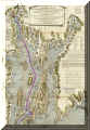 Map. This map,
courtesy of webmaster Concannon of www.gaspee.org is important to study if you
want to understand further the geography of the attack. Click the
thumbnail image to enlarge to view the map. Map. This map,
courtesy of webmaster Concannon of www.gaspee.org is important to study if you
want to understand further the geography of the attack. Click the
thumbnail image to enlarge to view the map.
Distances. Present day maps show the following approximate rowing
distances to Gaspee Point:
- From Bristol: 11 miles northwest (crew would have been
rowing with the tide on the evening of June 9th).
- From Providence: 6 miles south (crew would have been rowing against the
tide). Based on average rowing speeds, it would take about three
hours to row to the point of attack. By starting as they did, about 10 p.m.,
the attackers timed their movements to arrive just as the moon set,
and the night was as dark as it could be.
- From Newport: 17 miles north-northwest.
|

 Map. This map,
courtesy of webmaster Concannon of www.gaspee.org is important to study if you
want to understand further the geography of the attack. Click the
thumbnail image to enlarge to view the map.
Map. This map,
courtesy of webmaster Concannon of www.gaspee.org is important to study if you
want to understand further the geography of the attack. Click the
thumbnail image to enlarge to view the map.